Technical Discussion: First Alert Weather Days for a wet & windy weekend!
For any Alerts in effect for CT, click: here.
THIS MORNING…
It’s a pretty nice start to this Friday. The almost full harvest moon is shining brightly this morning with mostly clear skies! Any clouds you see out there are courtesy of a developing coastal storm that’s to our south. It’s a tad breezy, too. Temperatures, by daybreak, bottom out in the upper 40s and lower 50s (milder than the past couple of nights, seasonably so).
TOMORROW…
With high pressure anchored to our northwest and strengthening low pressure offshore to our southeast, our northeasterly breeze will intensify as we close out the workweek. Gusts up to 30mph are possible. Clouds will be increasing as the coastal storm approaches, as will rain chances through the late evening hours.
THE FINAL WEEKEND OF SEPTEMBER...
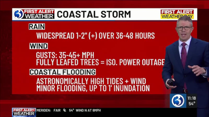
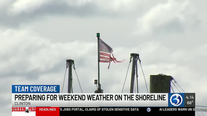
The 4th weekend of September will be greatly influenced by a slow-moving coastal storm. It will certainly impact outdoor plans, that’s why Saturday and Sunday are *First Alert Weather Days.*
We’re expecting wind gusts to reach 40-50 mph and since our trees are still fully leafed, limbs/branches could come down leading to isolated power outages. Also, it will be raw with temps running nearly 10° below normal. When it comes to rain, 1-2” likely adds up across the state (perhaps locally higher amounts). Even if heavier, the rain comes over a 36-48 hour window of time, so the threat for flooding is low. Something else we’ll be monitoring: the potential for ‘coastal’ flooding thanks to astronomically high tides (we have the full ‘harvest’ moon this weekend). It will come down to the track which dictates not only where the heaviest rain sets up and where the strongest wind gusts will be realized, but also wind direction. An onshore (easterly, or east-southeast) wind would push more water into the Sound, increasing the possibility for minor inundation along the CT coastline. However, as the track is coming into focus, we should have a northeasterly (offshore) wind… lowering the threat. Currently, up to 1′ of inundation is possible during high tide cycles (which equates to minor flooding).
The one thing that seems clear, currently, is that we won’t get the *worst* of the storm. It’s E/SE MA, the Cape/Islands that will receive the brunt of it (the strongest wind, the most rain, coastal flooding/erosion).
We will continue fine tuning the forecast, so stay with the First Alert Weather Team as this is an evolving timeframe!
NEXT WEEK…
While the coastal storm may be slow to depart with lingering showers Monday, we could see partial clearing as the day progresses. Thereafter we turn drier, brighter... also less windy and milder! Tuesday, we anticipate seasonable temps, then for highs above average (in the low to mid-70s) by Wednesday into Thursday.
Click to download the WFSB Weather App for iOS
Click to download the WFSB Weather App for Android
The First Alert Weather Team
------------------
SEPTEMBER 13 HEAVY RAIN...
Heavy rain and thunderstorms on the morning of Sunday, September 13 led to flash flooding in parts of the state. A widespread 1-2″ of rainfall fell in inland CT (1.07″ was recorded at Bradley Airport). Closer to the shoreline, rain totals were much higher - Bridgeport Airport saw 4.25″ (breaking a daily rainfall record for September 13), and Stamford recorded 7.47″.
------------------
WETTEST SUMMER ON RECORD...
On August 23, Bridgeport saw over 2″ worth of rainfall, with the total for Meteorological Summer (June, July, and August) up to 21.24″, officially breaking the record for wettest summer on record in Bridgeport. The previous record holder was the summer of 1972, with 20.23″ of rainfall - climate records in Bridgeport date back to the late 1940s.
------------------
AUGUST 13 STORMS...
Straight-line wind damage occurred on a line from Milford to East Haven around 1:30 a.m. on Thursday, August 13th. The path length for the downburst was 8.5 miles; the path width was 1.1 miles at its widest. Significant damage occurred in Milford, Orange and New Haven. There were reports of trees on houses and cars. A wall collapsed and the roof was lifted on a building on the Milford/Orange town line. Gusts were estimated to be between 85 and 105 mph. An anemometer at Lighthouse Point measured 103 mph, one at Morgan Point measured 97 mph and one at Silver Sands Beach measured 86 mph.
------------------
AUGUST 7 STORMS...
A cluster of thunderstorms moved through Connecticut during the evening on August 7. Storms were strong and, at times, severe. Trees were uprooted with over 15,000 outages reported. Flash flooding occurred as well, with rainfall rates between 1 and 2″ per hour under the downpours.
------------------
AUGUST 3 HEAVY RAIN...
Heavy rain led to numerous occasions of flooding across CT. In total, 1 to nearly 5″ of rain was measured. Officially, 3.59″ was received at Bradley Airport; meanwhile in Bridgeport, 0.97″ was received. Both of which set daily records for the 3rd of August.
------------------
JULY 28-30 HEAVY RAIN...
A slow-moving upper-level low brought rounds of rain, heavy at times. Downpours were more isolated on July 28th, while the heaviest and steadiest rain fell on July 29th. Rain totals were generally between 1 and 3″, but some areas ended up between 4 and 6″, including the Hartford Area where 4.30″ fell between July 28th and July 29th.
------------------
JULY 21 HEAVY RAIN...
Tropical moisture was pushed into Connecticut along a warm front on Tuesday, July 21. There were multiple reports of flash flooding, focused mostly on southern and western CT. Fairfield county received 5″ of rain with radar estimates up to 6″, while New Haven county reported amounts between 3 and 5″. Elsewhere, 1-3″ of rain fell.
------------------
JULY 5-7 HEAVY RAIN...
On Sunday, July 5th, showers began across parts of Connecticut as a boundary crept northward and then stalled out. However, it was overnight into Monday, July 6th when the rainfall really ramped up. Downpours were embedded within the steady rain. Showers ended Tuesday, but not before adding more accumulation to the already impressive totals... parts of Fairfield county received over 5″ of rain, with Danbury recording 5.91″ officially within that timeframe! Elsewhere at the shoreline, a widespread 3-5″ of rain fell, while northern CT ended up with 1-2″ of rain. Flood advisories were focused on the I-95 corridor through the evening hours on Monday. The Still River at Brookfield reached the moderate flood stage.
------------------
JULY 4th SEVERE STORMS...
On the evening of July 4th, after a hot and humid day, a cold front brought severe storms to Connecticut. A severe thunderstorm watch was issued across the state, with the first warnings being issued in the evening hours. While there was a line of severe-warned storms heading into CT, a rogue cell out ahead of the line was dropping large hail and bringing damaging wind gusts. That was responsible for the reports of golf ball-sized hail in Forestville and Bristol. The storms moved from west to east, tagged as “destructive” at one point (gusts to 80 mph!) Many towns reported downed trees and power lines, blocking roads and turning out the lights. Torrington, Harwinton and Madison were some of the hardest hit towns. Outages peaked at over 100,000 between UI and Eversource.
------------------
THE 2nd HEAT WAVE OF 2026 & JULY 2 RECORD...
The second heat wave of 2026 began on Tuesday, June 30 as temperatures peaked at 90. By Wednesday, July 1, temperatures soared to 95. The heat peaked on Thursday. We reached the 100 degree mark in the Hartford area, breaking the old record of 99 (set in 1966). The last time it was 100° in the Hartford Area was on July 21, 2019. Heat index values peaked between 105 and 115 with an Extreme Heat Warning across Connecticut. Bridgeport’s record was 100 (also set in 1966), but we fell short as the high was 97... however, we did tie the record high minimum temperature of 73 there. On July 3rd, temperatures reached 98, extending the heat wave.. The heat wave continued into day 5 on the 4th of July with temperatures reaching 95 for the Hartford Area.
------------------
COOL & WET MEMORIAL DAY WEEKEND...
An area of low pressure meandered south of Connecticut, keeping Memorial Day Weekend unsettled and cool. A statewide 1-2″ of rain fell over the course of 72 hours, with Sunday being the wettest day of the stretch. It was unseasonably cool (the Hartford Area high was 60 Saturday, 57 Sunday). The sun *did* finally come out Monday evening!
------------------
MAY 19 HEAT…
As soon as the temperature hit 90 (Bradley Airport) at Noon on Tuesday, our 1st heat wave of the year became official. But it got hotter. With a high of 96, a new May 19th record for the Hartford Area was achieved (prior record of 94 was from 1962). And, one must go back to July 29th of last year to find a day equally as hot, making May 19th the hottest day in nearly 10 months! Wednesday, the 20th, we managed to eek out 90 degrees at Bradley, thus bringing our heat wave to four days!
On the 19th, at Bridgeport, the temperature reached 88 degrees. While certainly warm, it was 1° from the record high that was set in 2017!
APRIL 21 RECORD COLD...
Temperatures on Tuesday, 04.21 bottomed out at 27 for the Hartford Area. This tied the record low of 27 from 1961. In Bridgeport, the temperature was 33, so the record of 29 from 1956 was safe.
------------------
APRIL 16 HEAT...
Temperatures on Thursday, 04.16 peaked at near record levels. The Hartford Area (as measured at Bradley International Airport) reached 90! While this fell short of the record of 92, it is the third earliest we’ve hit 90 since records began in 1905. Bridgeport reached 83, 2 degrees shy of the record of 85.
------------------
MARCH RECORD WARMTH...
Monday, March 9th, was one for the record books, at least in Bridgeport where the record high of 64 from 2021 was tied! Meanwhile, for the Hartford Area, it was mild but not warm enough to get remotely close to the March 9th record of 81. The temp managed to hit 70, the first time to do so since October 19th!
While the 9th was notable for the shoreline, Tuesday, March 10th was record-shattering for the Hartford Area as the temperature reached June-like levels. The March 10th record high was 72 from 2016 – we hit 79! Wednesday was also unseasonably warm, with an official high temperature of 74... just *1* degree shy of the record of 75 (set in 1977).
------------------
METEOROLOGICAL WINTER...
Meteorological winter ran from 12.01 to 02.28, and it was both cold and snowy compared to average. The average temperature was 25.6°, a full 4.1° below average. During the season, 52.3″ of snow fell, 13.2″ more than normal. In Bridgeport, an impressive 55.9″ of snow fell, which is a whopping 31.2″ above average!
------------------
BLIZZARD CALVIN...
Three NWS sites met blizzard criteria in Connecticut: Bridgeport, New Haven and Groton/New London. The criteria? Visibility of 1/4 mile or less and wind speeds (sustained or frequent gusts) of 35 mph or higher... over at least a 3 hour period. Additionally, the snowfall reports were impressive. Shoreline towns, especially in southeastern Connecticut, received 20″ and higher, with an official report of 30.8″ in Stonington and 2 feet in Mystic. Wind gusts reached 55 mph along the shoreline.
We named this storm Blizzard Calvin, following our naming tradition that dates back to 1971. The last blizzard in our area was over a decade ago, Blizzard Charlotte, in February of 2013. While it dropped 22.3” in the Hartford area, the jackpot was in Hamden where 40″ was measured!
------------------
WINTER STORM BENJAMIN...
Winter Storm Benjamin was the biggest snowstorm CT has experienced in almost a decade. The Hartford Area received 17.3″, beating out the 16.2″ that fell between February 18-19 in 2017. It produced a widespread 12-20″ of snow with some locally higher amounts. The jackpot was in Falls Village, where 22.0″ fell! While there was a bit of sleet that mixed in along the shoreline, official observations still eclipsed the 12″ mark.
The snow ramped up on Sunday, January 25th, spreading across Connecticut around sunrise. Snowfall rates were increasing quickly, with observed rates of 1-2″ by the afternoon. With air temperatures in the single digits, there was certainly a fluff factor at play! This also meant it felt cold outside... with the breeze, wind chill values were below zero for most of the day. The snow came down steadily and heavily through the evening, tapering off at night.
------------------
DID YOU FEEL IT, HEAR IT?
At 5:36 pm Wednesday, January 7th, the seismometer at the East Haddam Historical Society Museum measured a small earthquake. According to the USGS, it was located 1 miles south of Moodus, 5.6 miles deep and measured 1.9 magnitude. These quakes/tremors lead to the commonly known “Moodus Noises” that historically occur near/around Moodus, hence the name.
------------------
2025...
The numbers are in, and 2025 did not have big departures from average. The average temperature was 51.5°, 0.5° above normal. August, November and December were cooler than normal, but the rest of the year was warmer. Total precipitation (rain and the liquid equivalent of anything frozen) was a little below average with a total of 46.63″. This is only 0.42″ shy of average (the Hartford Area averages 47.05″). Snow for the calendar year was below average, too. Only 27.2″ fell, while average is 51.7″. There were *0* confirmed tornadoes in Connecticut, the first time since 2017.
------------------
WINTER STORM ABRAHAM...
An area of low pressure moving just to our south brought the first significant snowfall of the season - and our first named storm of winter - to Connecticut. Snow began on the evening of Friday, December 26th and continued overnight through the morning of Saturday, December 27th before dissipating.
Bands of heavy snow brought observed snowfall rates of 1-3″ per hour at times Friday evening. Winter Storm Abraham produced over 6″ of snowfall in many areas. Some of the highest reports were across central and western CT: New Milford - 10.5″, New Preston - 9.9″, Meriden - 9.0″, Naugatuck - 8.5″, Higganum - 8.0″ & Bristol- 8.0″.
------------------
DECEMBER 19 RECORD WARMTH, WIND AND RAIN...
A potent storm system moved through the Great Lakes on Friday, December 19. Ahead of the cold front, southerly winds across Connecticut gusted up to and over 60 miles per hour! Some notable gusts: 67 mph in Groton, 64 mph in Willimantic, 63 mph in Middletown, 60 mph in Berlin. Scattered power outages were reported across Connecticut. Also, about an inch of rain fell throughout Connecticut.
That strong southerly wind brought record warmth to Connecticut. For Bradley, where the Hartford Area records are kept, the temperature peaked at 58... beating the old record of 54 (set in 1949) by several degrees. In Bridgeport, the temperature climbed to 57, tying the record of 57 set in 1967.
------------------
DECEMBER 5 RECORD COLD...
High pressure moved in behind an Arctic front on December 5. Low temperatures were in the single digits and teens. In Bridgeport, we set a new daily record low temperature of 15 just before sunrise - breaking the previous record from 1989 by two degrees. Climate records in Bridgeport date back to 1948. The Hartford Area fell to 5 degrees. The record is 3, set in 1976.
------------------
DECEMBER 2 SNOW, ICY MIX AND RAIN...
On December 2, a coastal storm brought a mix of snow, freezing rain, sleet and rain to Connecticut. It began in the morning and wrapped up in the evening. Snow accumulated along and northwest of I-84, with the highest totals close to the Massachusetts border (5.0″ in Canaan, 4.0″ in Simsbury). It was also the first measurable snow at Bradley with 2.4″ recorded. The roads were quite slick with multiple spin-outs and crashes reported. This was a rain event for the shoreline from start to finish, dropping almost an inch of rain in SE CT.
------------------
OCTOBER 30 & 31 WIND & RAIN...
On October 30, low pressure moved up the Appalachians, bringing a slug of rain to Connecticut. Rain ramped up in the afternoon and evening, ending after midnight on October 31. Some notable totals: 3.99″ in Hamden, 3.94″ in Waterbury, 3.26″ in Bristol. Southern and Central CT saw totals in the 2-4″ range, while the northern part of the state saw 1-2″ fall. Wind gusts picked up, too, with the highest gust of 52 mph occurring in Bridgeport (at BDR). Most towns saw gusts between 40 and 50 mph on both 10.30 and 10.31.
------------------
OCTOBER 10th COLD WEATHER…
With dry air and a calm wind under a clear sky… the temperature dropped to 29 degrees at Bradley thus tying the record set back in 1989! This is also notable since the last time the temp (for the Hartford Area) was below 40 was back on May 12th, the last time it was lower than 35 was on April 21st! Bridgeport got down to 40, nowhere near the record of 33 set back in 1979.
------------------
AUGUST ‘25 & METEOROLOGICAL SUMMER...
August 2025 finished with an average temperature of 69.6°, and impressive 2.9° below normal. This is also noteworthy as it is the first month since November ‘23 to finish below normal, ending a stretch of 21 consecutive months warmer than normal! A total of 2.45″ fell for the Hartford Area (as measured at Bradley International Airport), 1.76″ below normal.
Meteorological summer ran from 06.01 to 08.31, and it was pretty close to normal for the Hartford Area. The average temperature was 72.2°, just 0.3° above normal. During the season, 12.39″ of rain fell, only 0.27° below normal. In Bridgeport, however, it was quite dry... only 3.85″ of rain fell during the entire season! That makes it the driest summer on record (since 1948). Previously, the driest summer was in 1995 when 4.13″ of rain fell.
------------------
AUGUST 20 RAIN & COOLNESS...
August 20th was a chilly, raw day in Connecticut. In fact, temperatures peaked at unseasonably cool levels, setting a new record for the Hartford Area (63 on 08.20 beat the previous coolest high of 70 from 1922). The record for Bridgeport was 70 set in 1990, which was tied. Rain fell heavily statewide, with totals over 3″ in parts of Litchfield and Fairfield counties.
Copyright 2026 WFSB. All rights reserved.